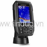
Fishfinder/Chartplotter Combo With 5” VGA Display
- 5” VGA display
- Garmin HD-ID™ sonar and DownVü™ scanning sonar for a nearly photographic view of fish and structure under the boat
- Available with preloaded LakeVü™ HD or BlueChart® g2 coastal mapping
- Transmit power (RMS)/(Peak to Peak): 500 W/4,000 W, includes water surface temperature
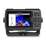
The echoMAP 50dv combination fishfinder/chartplotter with 5” color display has built-in advanced Garmin HD-ID and DownVü scanning sonar. DownVü provides a nearly photographic view of fish and structure under the boat.
The built-in 10 Hz GPS/GLONASS receiver updates your position and heading 10 times per second to display more fluid vessel movement, which makes it much easier to accurately mark and navigate to 5,000 waypoints. The echoMAP 50dv also includes sonar-recording capability that coordinates the timing of the sonar return with your boat's position and saves digital information for playback on a computer using HomePort™ planning software. For even more functionality, wirelessly connect to Apple® (mobile digital device) for BlueChart® Mobile.
Available with preloaded LakeVü HD maps — more than 17,000 lakes plus more than 5,700 HD lakes with 1’ contours shoreline to shoreline — or BlueChart g2 and BlueChart g2 Vision coastal maps.
Physical & Performance
|
|
Unit dimensions, WxHxD
|
5.9" x 6.1" x 2.4" (15.0 x 15.5 x 6.1 cm)
|
|
Display size, WxH
|
3.0" x 4.0"; 5.0" diagonal
(7.6 x 10.2 cm; 12.7 cm diagonal)
|
|
Display resolution, WxH
|
480 x 640 pixels
|
|
Display type
|
VGA display
|
|
Weight
|
1.6 lbs (0.7 kg)
|
|
Water rating
|
IPX7
|
|
Receiver
|
10 Hz high-sensitivity
|
|
Antenna
|
Internal only
|
|
Mounting options
|
Bail, flat or flush
|
|
Power consumption
|
Max power usage at 10 Vdc: 27 W
Typical current draw at 12 Vdc: 450 mA
Max current draw at 12 Vdc: 2.7 A
|
Maps & Memory
|
|
Preloaded maps
|
Yes (depending on version)
|
|
Accepts data cards
|
2 microSD™ cards
|
|
Waypoints
|
5,000
|
|
Routes
|
100
|
|
Track log
|
50,000 points; 50 saved tracks
|
Features & Benefits
|
|
Garmin Radar compatible
|
No
|
|
Garmin Sonar compatible
|
Yes
|
|
NMEA 2000® compatible
|
No
|
|
NMEA 0183 compatible
|
Yes
|
|
Garmin Marine Network™ compatible
|
No
|
|
Garmin SmartMode compatible (customizable monitor presets)
|
No
|
|
Supports AIS (tracks target ships position)
|
Yes
|
|
Supports DSC (displays position data from DSC-capable VHF radio)
|
Yes
|
|
Tide tables
|
Yes
|
|
Garmin Meteor Audio System compatible
|
No
|
|
Supports Fusion Lync compatible marine radios
|
No
|
|
GSD™ Black Box sonar support
|
No
|
|
GCV™ Black Box sonar support
|
No
|
|
SiriusXM™ Weather & Radio compatible
|
No
|
|
BlueChart® Mobile (planning) compatible
|
Yes
|
|
Garmin Helm compatible
|
No
|
|
GRID™ (Garmin Remote Input Device) compatible
|
No
|
|
Wireless remote compatible
|
No
|
|
Wireless mouse compatible
|
No
|
Sonar Features & Specifications
|
|
Dual-frequency (50/200 kHz) sonar capable
|
Yes
|
|
Dual-beam (77/200 kHz) sonar capable
|
Yes
|
|
Frequencies supported
|
50/77/200 kHz, DownVü
|
|
Transmit power
|
500 W (RMS) / 4,000 W (peak to peak)
|
|
CHIRP sonar technology
|
No
|
|
DownVü™
|
Yes (built-in)
|
|
SideVü™
|
No
|
|
Voltage range
|
10-32 Vdc input
|
|
Maximum depth
|
2,300 ft @ 77 kHz, freshwater
1,100 ft @ 77 kHz, saltwater
(depth capacity is dependent on water bottom type and other water conditions)
|
|
Bottom lock (shows return from the bottom up)
|
Yes
|
|
Water temperature log and graph
|
Yes
|
|
Sonar recording
|
Yes
|
|
Sonar history rewind
|
No
|
Connections
|
|
NMEA 0183 input ports
|
2
|
|
NMEA 0183 output ports
|
2
|
|
Video input ports
|
None
|
|
Video output ports
|
None
|
|
Wireless connectivity
|
Yes
|
|
Garmin Marine Network™ ports
|
None
|
- echoMAP 50dv with preloaded U.S. LakeVü™ HD or U.S. BlueChart® g2 coastal maps (depending on the version)
- 8-pin all-in-one 77/200 kHz HD-ID™/DownVü™ transducer with transom and trolling motor mounts
- Power/data cable
- Tilt/swivel mount
- Flush mount
- Protective cover
- Documentation


